
Miróbriga: Difference between revisions
m Open access bot: hdl updated in citation with #oabot. |
|||
| (87 intermediate revisions by 36 users not shown) | |||
| Line 1: | Line 1: | ||
{{short description|Iron Age and Roman site in Portugal}} |
|||
{{Geobox|Building |
|||
{{Infobox building |
|||
<!-- *** Heading *** --> |
|||
| name |
| name = Mirobriga |
||
| native_name |
| native_name = |
||
| native_name_lang = <!-- images --> |
|||
| other_name = Archaeological Ruins of Miróbriga |
|||
| |
| logo = |
||
| |
| logo_size = |
||
| logo_caption = |
|||
<!-- *** Image *** --> |
|||
| image |
| image = Miróbriga (20).jpg |
||
| image_size = |
|||
| image_caption = The ruins of the Roman villa of Miróbriga |
|||
| |
| image_caption = The ruins of the main temple at the forum |
||
<!-- |
<!-- map -->| map_type = |
||
| pushpin_relief = |
|||
| official_name = Estação Arquelógica de Miróbriga |
|||
| |
| image_map = |
||
| map_caption = Location of the archaeological site in the municipality of Santiago do Cacém |
|||
| nickname = |
|||
<!-- location -->| location = [[Santiago do Cacém (parish)|Santiago do Cacém]] |
|||
<!-- *** Symbols *** --> |
|||
| |
| address = |
||
| |
| location_city = |
||
| location_country = {{flag|Portugal}} |
|||
<!-- *** Country *** --> |
|||
| coordinates = {{coord|38|0|34.88|N|8|41|1.74|W|display=inline,title}} |
|||
| country = {{flag|Portugal}} |
|||
<!-- stats -->| former_names = |
|||
| state_type = Region |
|||
| alternate_names = Castelo Velho de Santiago do Cacém |
|||
| state = [[Alentejo]] |
|||
Termas de São Brás |
|||
| region_type = Sub-region |
|||
Herdade dos Chãos Salgados |
|||
| region = [[Alentejo Litoral]] |
|||
| |
| etymology = |
||
| status = |
|||
| municipality = [[Santiago do Cacém Municipality|Santiago do Cacém]] |
|||
| cancelled = |
|||
<!-- *** Locations *** --> |
|||
| topped_out = |
|||
| location = [[Santiago do Cacém (parish)|Santiago do Cacém]] |
|||
| building_type = [[Ancient Roman architecture|Roman ruins]] |
|||
| elevation = 226 |
|||
| architectural_style = [[Roman architecture|Roman]] |
|||
| prominence = |
|||
| |
| material = Stone |
||
| |
| classification = |
||
| |
| altitude = |
||
| |
| namesake = |
||
| groundbreaking_date = |
|||
| long_d = 8 |
|||
| |
| start_date = |
||
| |
| stop_date = |
||
| |
| est_completion = |
||
| completion_date = |
|||
<!-- *** Dimensions *** --> |
|||
| |
| opened_date = |
||
| inauguration_date = |
|||
| length_orientation = Southwest-Northeast |
|||
| |
| closing_date = |
||
| demolition_date = |
|||
| width_orientation = Northwest-Southeast |
|||
| destruction_date = |
|||
| height = |
|||
| |
| cost = |
||
| |
| ren_cost = |
||
| |
| client = |
||
| owner = Portuguese Republic |
|||
<!-- *** Features *** --> |
|||
| |
| affiliation = |
||
| |
| height = |
||
| architectural = |
|||
| style = [[Roman architecture|Roman]] |
|||
| structural_system = |
|||
| material = Stone |
|||
| |
| size = |
||
| |
| floor_count = |
||
| floor_area = |
|||
<!-- *** History & management *** --> |
|||
| |
| elevator_count = |
||
| |
| grounds_area = |
||
| |
| architect = |
||
| architecture_firm = |
|||
| established1_type = Initiated |
|||
| |
| developer = |
||
| |
| engineer = |
||
| |
| known_for = |
||
| website = http://mirobriga.drealentejo.pt/ |
|||
<!-- *** Access *** --> |
|||
| |
| embed = |
||
| |
| embedded = |
||
| references = |
|||
| visitation_date = Mondays and on [[New Year|1 January]], [[Easter Sunday]], [[May Day|1 May]] and [[Christmas|25 December]] |
|||
| |
| footnotes = |
||
<!-- *** UNESCO etc. *** --> |
|||
| whs_name = |
|||
| whs_year = |
|||
| whs_number = |
|||
| whs_region = |
|||
| whs_criteria = |
|||
| iucn_category = |
|||
<!-- *** Free fields *** --> |
|||
| free = [[IGESPAR|Instituto Gestão do Patrimonio Arquitectónico e Arqueológico]] |
|||
| free_type = Management |
|||
| free1 = |
|||
| free1_type = Operator |
|||
| free2 = 9:00 a.m.-12:30 p.m.; 2:30 p.m.-5:30 p.m. |
|||
| free2_type = Tuesday-Saturday |
|||
| free3 = 9:00 a.m.-12:30 p.m.; 2:30 p.m.-5:30 p.m. |
|||
| free3_type = Sunday |
|||
| free4 = Property of Public Interest |
|||
| free4_type = Status |
|||
| free5 = Decree No.30/762, DG No.225, 26 September 1940 |
|||
| free5_type = Listing |
|||
<!-- *** Maps *** --> |
|||
| map = |
|||
| map_caption = Location of the archaeological site in the municipality of Santiago do Cacém |
|||
| map_size = 235 |
|||
| map_background = |
|||
| map_locator = |
|||
| map_locator_x = 63 |
|||
| map_locator_y = 29 |
|||
<!-- *** Website *** --> |
|||
| commons = Miróbriga |
|||
| website = http://mirobriga.drealentejo.pt/ |
|||
<!-- *** Footnotes *** --> |
|||
| footnotes = |
|||
}} |
}} |
||
{{GeoGroup}} |
|||
'''Miróbriga''' is an ancient [[Ancient Rome|Roman]] villa located near the village and civil parish of [[Santiago do Cacém (parish)|Santiago do Cacém]], in the [[Santiago do Cacém Municipality|municipality of the same name]] in the south-west of [[Portugal]]. The Romans were excavated, revealing a that the [[Ancient Rome|Roman villa]] occupied the site of an ancient [[Iron Age]] settlement, that existed since the 9th century B.C. |
|||
'''''Mirobriga''''' or '''''Mirobriga of the Celts''''' (''Mirobrigensis qui celtici cognominantur - Plin. Nat. IV 118'') [[File:Openstreetmap logo.svg|20px|link=http://www.openstreetmap.org/?mlat=38.00983&mlon=-8.68417&zoom=18|alt=Localização precisa no OSM]] was an ancient town in the westernmost part of [[Lusitania]] during the Iron Age and Roman Times that was mentioned by [[Pliny the Elder]] and [[Ptolemy]]. |
|||
Despite some debate,<ref>{{Cite journal |last=d'Encarnação |first=José |date=1996 |title=Problemas em aberto na epigrafia mirobriguense |url=https://digitalis-dsp.uc.pt/bitstream/10316.2/45445/5/Problemas_em_aberto_na_epigrafia_mirobrigense.pdf2.png |journal=Conimbriga |volume=35 |pages=129–146 |doi=10.14195/1647-8657_35_6 |via=Universidade de Coimbra|doi-access=free |hdl=10316/42388 |hdl-access=free }}</ref> the city is generally associated with the archaeological site of '''''Castelo Velho de Santiago do Cacém''''' (''Herdade dos Chão Salgados'') located near the village and civil parish of [[Santiago do Cacém]], in the municipality of the same name in the south-west of Portugal. |
|||
The commercial area developed around the Forum. The [[Thermae|baths]], among the best preserved in Portugal, consist of two adjoining buildings, possibly for male and female use respectively. The residential areas are still little known. Relatively close to the baths, there is a bridge with a single, semicircular arch. The [[Circus (building)|hippodrome]], the only one whose entire ground plan is completely known in Portugal, is located further from the centre. |
|||
The ruins were first mentioned by [[André de Resende]] in the 16th century, who also made the association with the toponym. The site is also known as '''Roman ruins of Mirobriga''' and '''Roman city of Mirobriga'''.<ref name="SIPA">{{cite web |last=Mendonça |first=Isabel |year=1992 |editor=SIPA |title=Área do Castelo Velho, com as ruínas da cidade romana adjacente/Estação Arquelógica de Miróbriga/Ruínas de Miróbriga |url=http://www.monumentos.pt/Site/APP_PagesUser/SIPA.aspx?id=4076 |publisher=SIPA – Sistema de Informação para o Património Arquitectónico |language=pt |location=Lisbon, Portugal}}</ref><ref name="IGESPAR">{{citation |title=Área do Castelo Velho com as ruínas da cidade romana de Miróbriga |url=http://www.igespar.pt/en/patrimonio/pesquisa/geral/patrimonioimovel/detail/69756/ |year=2011 |editor=IGESPAR |access-date=26 July 2011 |archive-url=https://web.archive.org/web/20121001103616/http://www.igespar.pt/en/patrimonio/pesquisa/geral/patrimonioimovel/detail/69756/ |url-status=dead |location=Lisbon, Portugal |publisher=IGESPAR - Instituto Gestão do Patrimonio Arquitectónico e Arqueológico |language=pt |archive-date=1 October 2012}}</ref> |
|||
Archeology revealed that the site has been occupied since the [[Iron Age]], at least since the 5th/4th century BCE, but possibly going back to 9th century BCE. |
|||
With the Roman colonization came the need to administrate the new incorporated territories. As such, in some cases cities were created anew while in others, existing indigenous settlements were transformed to meet the requirements. The original settlement developed into a city in Roman times, and was occupied until the [[Early Middle Ages]]. |
|||
The [[Forum (Roman)|Forum]] occupied almost the entire area of the previous settlement, and around it a commercial area was developed. |
|||
The two [[Thermae|Balneae or Thermae]], set side-by-side, are among the best preserved in Portugal. Several domestic buildings have been identified in the last decades, mostly consisting of [[Domus|peristyle houses]]. |
|||
Relatively close to the baths, there is a bridge with a single arch. |
|||
The [[Circus (building)|Circus]], the only one whose entire ground plan is completely known in Portugal, is located further from the centre, approximately 500m to the south. |
|||
==History== |
==History== |
||
[[File:Mirobriga.JPG|thumb|235px|left|The layout of Mirobriga showing the chapel of São Brás (1), residential villas (2), ''thermae'' (3), bridge (4), accommodations (5), market (6) and forum (7)]] |
[[File:Mirobriga.JPG|thumb|235px|left|The layout of Mirobriga showing the chapel of São Brás (1), residential villas (2), ''thermae'' (3), bridge (4), accommodations (5), market (6) and forum (7)]] |
||
Excavations and investigations (W. Biers, 1988), suggest that the earliest settlement began to take shape in the 9th century B.C. ([[Iron Age]]), and that the defensive walls began appearing between the 4th-3rd century B.C. This settlement occupied an area of 11,800 m², with the population inhabiting the area along the embankment and north-east corner of Castelo Velho, of which only a wall and temple remains (alongside the Roman forum).<ref name="SIPA">{{cite web|url=http://www.monumentos.pt/Site/APP_PagesUser/SIPA.aspx?id=4076|title=Área do Castelo Velho, com as ruínas da cidade romana adjacente/Estação Arquelógica de Miróbriga/Ruínas de Miróbriga |publisher=SIPA – Sistema de Informação para o Património Arquitectónico|editor=SIPA|location=Lisbon, Portugal|language=Portuguese|first=Isabel |last=Mendonça |year=1992}}</ref> |
|||
=== Iron Age === |
|||
By about the second half of the 1st century Roman occupation began, expanding the site and occupying an area of 28,000 m². At this time the thermal baths and paved road along the southeast were constructed, reflecting the [[Flavian dynasty|Flavian]] economic prosperity.<ref name=SIPA/> Around the first half of the 2nd century, the construction of the Oriental baths and [[hippodrome]] was began, followed by a second phase of construction in the second half of the 2nd century and 3rd century. |
|||
The name of ''Castelo Velho'' (portuguese for ''Old Castle'') is a recurrent folk toponym for ancient sites and ruins, usually referring to sites predating Roman occupation. Material culture indicates a strong continental ([[Celts|celtic]]) influence, and, if this is really is the site of ''Mirobriga'', the suffix -''briga'' is also an indicator of the ethnic-cultural nature of the inhabitants. |
|||
The current state of the investigation suggest that the earliest occupation may go back to 9th century BCE. However, the known structures date only to the 4th–3rd century BCE. |
|||
Around the second half of the 2nd century, there were signs of abandon, that may reflect the period of political crisis caused by barbarian invasions during this period. By the end of the 4th century, there is a marked reduction in the population, although a level of continuity persisted on the site: primarily around the small Chapel of São Brás.<ref name=SIPA/> |
|||
This settlement is thought to have occupied only the hill of ''Castelo Velho'' and its slopes, an area of about 11,800 m<sup>2.</sup> |
|||
The ruins were rediscovered and referenced by André de Resende in the 16th century, but they were never fully studied until the 18th century.<ref name=SIPA/><ref name="IGESPAR">{{citation|url=http://www.igespar.pt/en/patrimonio/pesquisa/geral/patrimonioimovel/detail/69756/ |title=Área do Castelo Velho com as ruínas da cidade romana de Miróbriga |editor=IGESPAR |accessdate=26 July 2011 |year=2011|location=Lisbon, Portugal |publisher=IGESPAR - Instituto Gestão do Patrimonio Arquitectónico e Arqueológico |language=Portuguese}}</ref> |
|||
Because investigation has mainly focused on the Roman remains, the Iron Age occupation of the site is still largely unknown. Only one building has been excavated. It is usually referred to as the "Celtic temple", although its sacred function is still debated and could have equally been a domestic building.<ref>Fabião, Carlos (1998). O Mundo Indígena e sua Romanização na área céltica do território hoje português-vol. 1. Dissertação de Doutoramento. [S.l.]: Fac. Letras da Universidade de Lisboa. Policopiado. pp. 232–233</ref> |
|||
On 1 June 1992 the Instituto Português do Património Arquitectónico (IPPAR) (forerunner of [[IGESPAR|Institute for the Management of Architectural and Archaeological Heritage]] tookover the management of the site, by Decree-Law No.106F/92.<ref name=SIPA/> This was followed in 1996-1997 by the acquisition of the lands that surrounded the site, as part of the ''ZEP-Zona de Protecção Especial'' (''Special Protection Zone'') designation. On 1 February 1999, a dispatch (No.180/99) from the Ministries of Equipment, Planning and Territory Administration, Ministry of the Environment and the Ministry of Culture, recognized the importance of safeguarding the Roman ruins, and authorized the construction of an Interpretative Centre.<ref name=SIPA/> The project began in 2000, in a project designed by architect Paula Santos, that included a 700 m² space. |
|||
In Roman times the forum occupied almost the entire hill, possibly destroying the previous settlement.<ref name="SIPA" /> |
|||
=== Roman period === |
|||
By about the second half of the 1st century Roman occupation began, expanding the site and occupying an area of 28,000 m<sup>2</sup>. At this time the thermal baths and paved road along the southeast were constructed, reflecting the [[Flavian dynasty|Flavian]] economic prosperity.<ref name=SIPA/> Around the first half of the 2nd century, the construction of the Oriental baths and hippodrome was begun, followed by the second phase of construction in the second half of the 2nd century and 3rd century. |
|||
Around the second half of the 2nd century, there were signs of abandon, that may reflect the period of political crisis caused by barbarian invasions during this period. By the end of the 4th century, there is a marked reduction in the population, although a level of continuity persisted on the site: primarily around the small Chapel of São Brás.<ref name=SIPA/> |
|||
==Architecture== |
==Architecture== |
||
[[File:Miróbriga |
[[File:Miróbriga (35).jpg|thumb|[[Forum (Roman)|Forum]] area]] |
||
[[File:Miróbriga (62).jpg|thumb|Small, single-arch bridge]] |
|||
[[File:Miróbriga (59).jpg|thumb|A partial view of the [[Thermae]]]] |
|||
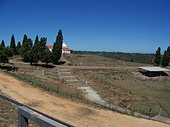
''Castelo Velho'' hill (245 metres) dominates the site that is one kilometre north-west from the urban centre of modern [[Santiago do Cacém]], which overlooks the northern plain of ''Chãos Salgados''.<ref name="SIPA" /> Miróbriga is situated in a privileged location, on the ancient roadways of the region with access to the coast. Within close proximity is the ''Windmill of Cumeadas''. |
|||
===Forum=== |
|||
''Castelo Velho'' (245 metres) overlooking, one kilometre north-west, the urban centre of [[Santigao do Cacém (parish)|Santiago do Cacém]], which dominates the northern plain of ''Chãos Salgados''.<ref name=SIPA/> Miróbriga is situated in a privileged location, on the ancient roadways of the region with access to the coast. Within close proximity is a Windmill of Cumeadas. |
|||
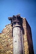
To the east of the baths is a small, single-arch bridge (at {{Coord|38.00926|-8.6836|name=Bridge}}), that provided access along the west–east access that leads to the [[Forum (Roman)|Forum]] (at {{coord|38.01042|-8.68393|name=Forum|display=inline}}), an [[Imperial cult|Imperial temple]] (to worship the [[Roman Emperors]]) and a temple dedicated to [[Venus (mythology)|Venus]].<ref name=SIPA/><ref name=IGESPAR/> Between these two are the remains of an older temple dedicated to the local divinity. North of the forum are the ruins of the market and the visitor's houses, separated by another road.<ref name=SIPA/><ref name=IGESPAR/> |
|||
===Baths=== |
|||
The settlement is structured around Roman roads with many paved accesses. Around the west-east axis are the ruins of the residential homes. To the east, are the former baths constructed over a canal and composed of two buildings in a "L" shape (''"Western Baths"'' and ''"Eastern Baths"'').<ref name=SIPA/><ref name=IGESPAR/> Each building has: an entry into the massage hall, a gymnasium, changing room, the bathing space, which included the ''frigidarium'' (cold baths, ''tepidarium'' (warm baths) and ''caldarium'' (hot baths) and a communal [[latrine]].<ref name=SIPA/><ref name=IGESPAR/> The halls are warmed by a [[hypocaust]]system that heated the floors of baths, which was located in the south part of the buildings. It was a subterranean system formed by pillars and arches, with tile, that allowed the circulation of warm air to produce heated environments, supported by kilns. |
|||
The settlement is structured around Roman roads with many paved accesses. Around the west–east axis are the ruins of the residential homes. To the east, are the former baths constructed over a canal and composed of two buildings in a "L" shape ("Western Baths" and "Eastern Baths", at {{coord|38.00932|-8.68407|name=Thermae|display=inline}}).<ref name=SIPA/><ref name=IGESPAR/><ref>{{cite web|url=http://www.portugalromano.com/2012/12/os-balnearios-de-mirobriga-filomena-barata/ |title=Os balneários de Miróbriga (Filomena Barata) |publisher=Portugal Romano |date=2012-06-22 |access-date=2014-05-04}}</ref> Each building has an entry into the massage hall, a gymnasium, [[Apodyterium|changing room]], the bathing space, which included the ''[[frigidarium]]'' (cold baths, ''[[tepidarium]]'' (warm baths) and ''[[caldarium]]'' (hot baths), and a communal [[latrine]].<ref name=SIPA/><ref name=IGESPAR/> The halls are warmed by a [[hypocaust]] system that heated the floors of baths, which was located in the south part of the buildings. It was a subterranean system formed by pillars and arches, with tile, that allowed the circulation of warm air to produce heated environments, supported by kilns. |
|||
To the east of the baths is a small, single-arch bridge, that provided access along the west-east access that leads to the ''"[[Forum (Roman)|forum]]"'', an Imperial temple (to worship the Roman Emporers) and a temple dedicated to [[Venus (mythology)|Venus]].<ref name=SIPA/><ref name=IGESPAR/> Between these two are the remains of an older temple dedicated to the local divinity. North of the forum are the ruins of the market and the visitors houses, separated by another road.<ref name=SIPA/><ref name=IGESPAR/> |
|||
===Circus=== |
|||
The [[hippodrome]] was a rectangular space with curved seating on the northern end, while segmented seat on the south, used for chariot or horse races.<ref name=IGESPAR/> It was a 370 metre by 75 metre space, bisected by a spine with posts on either end, and a triumphal arch on the south entrance.<ref name=SIPA/> |
|||
The Circus, located at {{coord|38.00224|-8.68369|name=Circus|display=inline}}, was a rectangular space with curved seating on the northern end, while segmented seat on the south, used for [[Chariot racing|chariot]] or horse races.<ref name=IGESPAR/> It was a 370 metre by 75 metre space, bisected by a spine with posts on either end and a triumphal arch on the south entrance.<ref name=SIPA/> |
|||
== Protection of the site == |
|||
The Interpretative Centre (the most recent addition) is located on an elevated area at the entrance to the site, with several paths leading away from this site into the ruins.<ref name=IGESPAR/> |
|||
On 1 June 1992, the Instituto Português do Património Arquitectónico (IPPAR) (forerunner of [[IGESPAR|Institute for the Management of Architectural and Archaeological Heritage]] took over the management of the site, by Decree-Law No.106F/92.<ref name="SIPA" /> This was followed in 1996-1997 by the acquisition of the lands that surrounded the site, as part of the ''ZEP-Zona de Protecção Especial'' (''Special Protection Zone'') designation. |
|||
On 1 February 1999, a dispatch (No.180/99) from the Ministries of Equipment, Planning and Territory Administration, Ministry of the Environment and the Ministry of Culture, recognized the importance of safeguarding the Roman ruins, and authorized the construction of an [[Interpretative Centre]].<ref name="SIPA" /> |
|||
The project began in 2000, in a project designed by architect Paula Santos, that included a 700 m<sup>2</sup> space. The Interpretative Centre (the most recent addition) is located on an elevated area at the entrance to the site, with several paths leading away from this site into the ruins.<ref name="IGESPAR" /> |
|||
== Gallery == |
|||
<gallery mode="packed"> |
|||
File:Mirobriga interpretative center.jpg|Mirobriga's interpretative center |
|||
File:View over residential area of Mirobriga.jpg|View of Mirobriga's residential area |
|||
File:Mirobriga Frescos.jpg|[[Fresco|Frescos]] covering the walls of a Mirobriga house |
|||
File:Stone-paved street in Mirobriga.jpg|Stone-paved street leading to the baths |
|||
File:Rear view of caldarium in Mirobriga.jpg|Rear view of a [[caldarium]] (hot room), East Baths |
|||
File:Side view of a caldarium in Mirobriga.jpg|Side view of a caldarium (hot room), West Baths |
|||
File:Mirobriga Roman Bridge.jpg|Bridge near the baths |
|||
File:Inscription in Mirobriga.jpg|[[Epigraphy|Inscription]] dedicated to a citizen of [[Italica]] |
|||
File:Imperial cult temple in Mirobriga.jpg|[[Imperial cult of ancient Rome|Imperial cult]] temple in the [[Forum (Roman)|Forum]] |
|||
File:Miróbriga by Henrique Matos 02.jpg|Decorative detail (imperial temple) |
|||
File:Tabernae Miróbriga.jpg|Shops along the path leading to the forum |
|||
</gallery> |
|||
==See also== |
|||
*[[Lusitania]] |
|||
*[[Sines Municipality|Sines]] (the bay of Sines was used as port by the ''civitas'' of ''Mirobriga'') |
|||
==References== |
==References== |
||
;Notes |
;Notes |
||
{{Reflist |
{{Reflist}} |
||
;Sources |
;Sources |
||
* {{citation |last=Cruz e Silva |first=João Gualberto da |title=Apontamentos e considerações sobre as pesquisas arqueológicas realizadas desde 1922 nos concelhos de Santiago do Cacém, Sines e Odemira|publisher=Arquivo de Beja |volume=3 |location=Beja, Portugal |year=1946 |language= |
* {{citation |last=Cruz e Silva |first=João Gualberto da |title=Apontamentos e considerações sobre as pesquisas arqueológicas realizadas desde 1922 nos concelhos de Santiago do Cacém, Sines e Odemira|publisher=Arquivo de Beja |volume=3 |location=Beja, Portugal |year=1946 |language=pt}} |
||
* {{citation |editor=MOP |publisher=Ministério das Obras Públicas/DGMEN |title=Obras em Monumentos Nacionais - Congresso Internacional de História da Arte, s.l. |year=1949 |location=Lisbon, Portugal|language= |
* {{citation |editor=MOP |publisher=Ministério das Obras Públicas/DGMEN |title=Obras em Monumentos Nacionais - Congresso Internacional de História da Arte, s.l. |year=1949 |location=Lisbon, Portugal|language=pt}} |
||
* {{citation |last=Almeida |first=D. Fernando de |contribution=Nota sobre os restos do circo romano de Miróbriga dos Célticos |title=Revista de Guimarães |volume=73 |issue= |
* {{citation |last=Almeida |first=D. Fernando de |contribution=Nota sobre os restos do circo romano de Miróbriga dos Célticos |title=Revista de Guimarães |volume=73 |issue=1–2 |location=Lisbon, Portugal|language=pt}} |
||
* {{citation |editor=MOP |publisher=Ministério das Obras Públicas |title=Relatório da Actividade do Ministério no ano de 1955 |location=Lisbon, Portugal |year=1956 |language= |
* {{citation |editor=MOP |publisher=Ministério das Obras Públicas |title=Relatório da Actividade do Ministério no ano de 1955 |location=Lisbon, Portugal |year=1956 |language=pt}} Barata, Maria Filomena, 1997, Miróbriga - Arquitectura e urbanismo (tese de mestrado apresentada na Faculdade de Letras do Porto)in https://www.academia.edu/807569/Mirobriga_Arquitectura_e_Urbanismo; Barata, Maria Filomena, Roteiro das Ruínas de Miróbriga (IPPAR) |
||
* {{citation |last=Correia |first=Susana |contribution=Estação arqueológica de Miróbriga (Santiago do Cacém). Balanço de uma investigação e perspectivas de intervenção futura |title=Anais da Real Sociedade Arqueológica Lusitana |volume=1, 2ª série |location=Santiago do Cacém, Portugal |year=1987 |language= |
* {{citation |last=Correia |first=Susana |contribution=Estação arqueológica de Miróbriga (Santiago do Cacém). Balanço de uma investigação e perspectivas de intervenção futura |title=Anais da Real Sociedade Arqueológica Lusitana |volume=1, 2ª série |location=Santiago do Cacém, Portugal |year=1987 |language=pt}} |
||
* {{citation |editor-last=Biers |editor-first=W. |title=Mirobriga - investigations at an Iron Age site in southern Portugal by the University of Missouri-Columbia, 1981-1986 |location=Oxford, England|publisher=Oxford University Press |year=1988 |language= |
* {{citation |editor-last=Biers |editor-first=W. |title=Mirobriga - investigations at an Iron Age site in southern Portugal by the University of Missouri-Columbia, 1981-1986 |location=Oxford, England|publisher=Oxford University Press |year=1988 |language=pt}} |
||
==External links== |
==External links== |
||
* {{pt}} [http://www.360portugal.com/Distritos.QTVR/Setubal.VR/Arqueologia/Ruinas_Mirobriga/ 360 |
* {{in lang|pt}} [https://web.archive.org/web/20100921174418/http://www.360portugal.com/Distritos.QTVR/Setubal.VR/Arqueologia/Ruinas_Mirobriga/ 360° Portugal Miróbriga ruins] |
||
* {{pt}} [http://mirobrigaeoalentejo.blogspot.com/ Miróbriga Blogspot - apontamentos e sentidos com Miróbriga e o Alentejo de fundo |
* {{in lang|pt}} [http://mirobrigaeoalentejo.blogspot.com/ Miróbriga Blogspot - apontamentos e sentidos com Miróbriga e o Alentejo de fundo] |
||
{{Pre-Roman peoples in Portugal}} |
|||
[[Category:Former populated places in Portugal]] |
|||
{{authority control}} |
|||
{{portugal-struct-stub}} |
|||
{{DEFAULTSORT:Mirobriga}} |
|||
[[de:Miróbriga]] |
|||
[[Category:Roman towns and cities in Portugal]] |
|||
[[es:Miróbriga]] |
|||
[[Category:Buildings and structures in Setúbal District]] |
|||
[[pt:Miróbriga]] |
|||
[[Category:Tourist attractions in Setúbal District]] |
|||
[[ru:Миробрига]] |
|||
[[Category:Museums of ancient Rome in Portugal]] |
|||
[[Category:Buildings and structures in Santiago do Cacém]] |
|||
Latest revision as of 14:42, 4 January 2024
| Mirobriga | |
|---|---|
.jpg) The ruins of the main temple at the forum | |
 | |
| Alternative names | Castelo Velho de Santiago do Cacém
Termas de São Brás Herdade dos Chãos Salgados |
| General information | |
| Type | Roman ruins |
| Architectural style | Roman |
| Location | Santiago do Cacém |
| Country | |
| Coordinates | 38°0′34.88″N 8°41′1.74″W / 38.0096889°N 8.6838167°W |
| Owner | Portuguese Republic |
| Technical details | |
| Material | Stone |
| Website | |
| http://mirobriga.drealentejo.pt/ | |
Mirobriga or Mirobriga of the Celts (Mirobrigensis qui celtici cognominantur - Plin. Nat. IV 118) ![]() was an ancient town in the westernmost part of Lusitania during the Iron Age and Roman Times that was mentioned by Pliny the Elder and Ptolemy.
was an ancient town in the westernmost part of Lusitania during the Iron Age and Roman Times that was mentioned by Pliny the Elder and Ptolemy.
Despite some debate,[1] the city is generally associated with the archaeological site of Castelo Velho de Santiago do Cacém (Herdade dos Chão Salgados) located near the village and civil parish of Santiago do Cacém, in the municipality of the same name in the south-west of Portugal.
The ruins were first mentioned by André de Resende in the 16th century, who also made the association with the toponym. The site is also known as Roman ruins of Mirobriga and Roman city of Mirobriga.[2][3]
Archeology revealed that the site has been occupied since the Iron Age, at least since the 5th/4th century BCE, but possibly going back to 9th century BCE.
With the Roman colonization came the need to administrate the new incorporated territories. As such, in some cases cities were created anew while in others, existing indigenous settlements were transformed to meet the requirements. The original settlement developed into a city in Roman times, and was occupied until the Early Middle Ages.
The Forum occupied almost the entire area of the previous settlement, and around it a commercial area was developed.
The two Balneae or Thermae, set side-by-side, are among the best preserved in Portugal. Several domestic buildings have been identified in the last decades, mostly consisting of peristyle houses.
Relatively close to the baths, there is a bridge with a single arch.
The Circus, the only one whose entire ground plan is completely known in Portugal, is located further from the centre, approximately 500m to the south.
History[edit]

Iron Age[edit]
The name of Castelo Velho (portuguese for Old Castle) is a recurrent folk toponym for ancient sites and ruins, usually referring to sites predating Roman occupation. Material culture indicates a strong continental (celtic) influence, and, if this is really is the site of Mirobriga, the suffix -briga is also an indicator of the ethnic-cultural nature of the inhabitants.
The current state of the investigation suggest that the earliest occupation may go back to 9th century BCE. However, the known structures date only to the 4th–3rd century BCE.
This settlement is thought to have occupied only the hill of Castelo Velho and its slopes, an area of about 11,800 m2.
Because investigation has mainly focused on the Roman remains, the Iron Age occupation of the site is still largely unknown. Only one building has been excavated. It is usually referred to as the "Celtic temple", although its sacred function is still debated and could have equally been a domestic building.[4]
In Roman times the forum occupied almost the entire hill, possibly destroying the previous settlement.[2]
Roman period[edit]
By about the second half of the 1st century Roman occupation began, expanding the site and occupying an area of 28,000 m2. At this time the thermal baths and paved road along the southeast were constructed, reflecting the Flavian economic prosperity.[2] Around the first half of the 2nd century, the construction of the Oriental baths and hippodrome was begun, followed by the second phase of construction in the second half of the 2nd century and 3rd century.
Around the second half of the 2nd century, there were signs of abandon, that may reflect the period of political crisis caused by barbarian invasions during this period. By the end of the 4th century, there is a marked reduction in the population, although a level of continuity persisted on the site: primarily around the small Chapel of São Brás.[2]
Architecture[edit]
.jpg)
.jpg)
.jpg)
Castelo Velho hill (245 metres) dominates the site that is one kilometre north-west from the urban centre of modern Santiago do Cacém, which overlooks the northern plain of Chãos Salgados.[2] Miróbriga is situated in a privileged location, on the ancient roadways of the region with access to the coast. Within close proximity is the Windmill of Cumeadas.
Forum[edit]
To the east of the baths is a small, single-arch bridge (at 38°00′33″N 8°41′01″W / 38.00926°N 8.6836°W), that provided access along the west–east access that leads to the Forum (at 38°00′38″N 8°41′02″W / 38.01042°N 8.68393°W), an Imperial temple (to worship the Roman Emperors) and a temple dedicated to Venus.[2][3] Between these two are the remains of an older temple dedicated to the local divinity. North of the forum are the ruins of the market and the visitor's houses, separated by another road.[2][3]
Baths[edit]
The settlement is structured around Roman roads with many paved accesses. Around the west–east axis are the ruins of the residential homes. To the east, are the former baths constructed over a canal and composed of two buildings in a "L" shape ("Western Baths" and "Eastern Baths", at 38°00′34″N 8°41′03″W / 38.00932°N 8.68407°W).[2][3][5] Each building has an entry into the massage hall, a gymnasium, changing room, the bathing space, which included the frigidarium (cold baths, tepidarium (warm baths) and caldarium (hot baths), and a communal latrine.[2][3] The halls are warmed by a hypocaust system that heated the floors of baths, which was located in the south part of the buildings. It was a subterranean system formed by pillars and arches, with tile, that allowed the circulation of warm air to produce heated environments, supported by kilns.
Circus[edit]
The Circus, located at 38°00′08″N 8°41′01″W / 38.00224°N 8.68369°W, was a rectangular space with curved seating on the northern end, while segmented seat on the south, used for chariot or horse races.[3] It was a 370 metre by 75 metre space, bisected by a spine with posts on either end and a triumphal arch on the south entrance.[2]
Protection of the site[edit]
On 1 June 1992, the Instituto Português do Património Arquitectónico (IPPAR) (forerunner of Institute for the Management of Architectural and Archaeological Heritage took over the management of the site, by Decree-Law No.106F/92.[2] This was followed in 1996-1997 by the acquisition of the lands that surrounded the site, as part of the ZEP-Zona de Protecção Especial (Special Protection Zone) designation.
On 1 February 1999, a dispatch (No.180/99) from the Ministries of Equipment, Planning and Territory Administration, Ministry of the Environment and the Ministry of Culture, recognized the importance of safeguarding the Roman ruins, and authorized the construction of an Interpretative Centre.[2]
The project began in 2000, in a project designed by architect Paula Santos, that included a 700 m2 space. The Interpretative Centre (the most recent addition) is located on an elevated area at the entrance to the site, with several paths leading away from this site into the ruins.[3]
Gallery[edit]
-
 Mirobriga's interpretative center
 -
 View of Mirobriga's residential area
 -
 Frescos covering the walls of a Mirobriga house
 -
 Stone-paved street leading to the baths
 -
 Rear view of a caldarium (hot room), East Baths
 -
 Side view of a caldarium (hot room), West Baths
 -
 Bridge near the baths
 -
 Inscription dedicated to a citizen of Italica
 -
 Imperial cult temple in the Forum
 -
 Decorative detail (imperial temple)
 -
 Shops along the path leading to the forum


See also[edit]
References[edit]
- Notes
- ^ d'Encarnação, José (1996). "Problemas em aberto na epigrafia mirobriguense". Conimbriga. 35: 129–146. doi:10.14195/1647-8657_35_6. hdl:10316/42388 – via Universidade de Coimbra.
- ^ a b c d e f g h i j k l Mendonça, Isabel (1992). SIPA (ed.). "Área do Castelo Velho, com as ruínas da cidade romana adjacente/Estação Arquelógica de Miróbriga/Ruínas de Miróbriga" (in Portuguese). Lisbon, Portugal: SIPA – Sistema de Informação para o Património Arquitectónico.
- ^ a b c d e f g IGESPAR, ed. (2011), Área do Castelo Velho com as ruínas da cidade romana de Miróbriga (in Portuguese), Lisbon, Portugal: IGESPAR - Instituto Gestão do Patrimonio Arquitectónico e Arqueológico, archived from the original on 1 October 2012, retrieved 26 July 2011
- ^ Fabião, Carlos (1998). O Mundo Indígena e sua Romanização na área céltica do território hoje português-vol. 1. Dissertação de Doutoramento. [S.l.]: Fac. Letras da Universidade de Lisboa. Policopiado. pp. 232–233
- ^ "Os balneários de Miróbriga (Filomena Barata)". Portugal Romano. 2012-06-22. Retrieved 2014-05-04.
- Sources
- Cruz e Silva, João Gualberto da (1946), Apontamentos e considerações sobre as pesquisas arqueológicas realizadas desde 1922 nos concelhos de Santiago do Cacém, Sines e Odemira (in Portuguese), vol. 3, Beja, Portugal: Arquivo de Beja
- MOP, ed. (1949), Obras em Monumentos Nacionais - Congresso Internacional de História da Arte, s.l. (in Portuguese), Lisbon, Portugal: Ministério das Obras Públicas/DGMEN
- Almeida, D. Fernando de, "Nota sobre os restos do circo romano de Miróbriga dos Célticos", Revista de Guimarães (in Portuguese), vol. 73, Lisbon, Portugal
- MOP, ed. (1956), Relatório da Actividade do Ministério no ano de 1955 (in Portuguese), Lisbon, Portugal: Ministério das Obras Públicas Barata, Maria Filomena, 1997, Miróbriga - Arquitectura e urbanismo (tese de mestrado apresentada na Faculdade de Letras do Porto)in https://www.academia.edu/807569/Mirobriga_Arquitectura_e_Urbanismo; Barata, Maria Filomena, Roteiro das Ruínas de Miróbriga (IPPAR)
- Correia, Susana (1987), "Estação arqueológica de Miróbriga (Santiago do Cacém). Balanço de uma investigação e perspectivas de intervenção futura", Anais da Real Sociedade Arqueológica Lusitana (in Portuguese), vol. 1, 2ª série, Santiago do Cacém, Portugal
{{citation}}: CS1 maint: location missing publisher (link) - Biers, W., ed. (1988), Mirobriga - investigations at an Iron Age site in southern Portugal by the University of Missouri-Columbia, 1981-1986 (in Portuguese), Oxford, England: Oxford University Press
External links[edit]
- (in Portuguese) 360° Portugal Miróbriga ruins
- (in Portuguese) Miróbriga Blogspot - apontamentos e sentidos com Miróbriga e o Alentejo de fundo
| National | |
|---|---|
| Geographic | |