Girardota: Difference between revisions
Content deleted Content added
No edit summary Tags: Mobile edit Mobile web edit |
No edit summary Tags: Mobile edit Mobile web edit |
||
| Line 28: | Line 28: | ||
|established_date = |
|established_date = |
||
|area_magnitude = |
|area_magnitude = |
||
|area_total_km2 = |
|area_total_km2 = 82.86 |
||
|area_total_sq_mi = |
|area_total_sq_mi = |
||
|area_land_km2 = |
|area_land_km2 = |
||
|area_land_sq_mi = |
|area_land_sq_mi = |
||
Revision as of 12:44, 24 March 2023
Girardota | |
|---|---|
Municipality and town | |
 | |
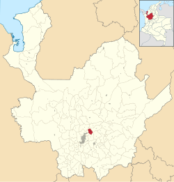
 Location of the municipality and town of Girardota in the Antioquia Department of Colombia | |
| Coordinates: 6°22′35.01″N 75°26′50.23″W / 6.3763917°N 75.4472861°W | |
| Country | |
| Department | |
| Area | |
| • Municipality and town | 82.86 km2 (31.99 sq mi) |
| • Urban | 3.77 km2 (1.46 sq mi) |
| Population (2020 est.)[1] | |
| • Municipality and town | 54,439 |
| • Density | 660/km2 (1,700/sq mi) |
| • Urban | 30,958 |
| • Urban density | 8,200/km2 (21,000/sq mi) |
| Time zone | UTC-5 (Colombia Standard Time) |
Girardota is a town and municipality in Antioquia Department, Colombia. Girardota is part of The Metropolitan Area of the Aburrá Valley.
References
- ^ Citypopulation.de Population of Girardota municipality]
6°22′35.01″N 75°26′50.23″W / 6.3763917°N 75.4472861°W


