
Bayanaul National Park
You can help expand this article with text translated from the corresponding article in Russian. (February 2009) Click [show] for important translation instructions.
|
This article contains content that is written like an advertisement. (January 2022) |
| Bayanaul National Park | |
|---|---|
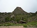
 View of the granite landscape of Bayanaul National Park, with Bulka mountain to the right | |
 | |
| Location | Pavlodar Province, Kazakhstan |
| Nearest city | Ekibastuz, Kazakhstan |
| Coordinates | 50°49′0″N 75°40′0″E / 50.81667°N 75.66667°E |
| Area | 68,453 ha |
| Max. elevation | 1,027 m |
| Min. elevation | 400 m |
| Established | August 12, 1985 |
Bayanaul National Park (Kazakh: Баянауыл ұлттық паркі, Baianauyl ūlttyq parkı; Russian: Баянаульский национальный парк) is a national park in Kazakhstan and is located on the outskirts of the Kazakh Uplands in the northeastern Pavlodar Province, 140 km from the city of Ekibastuz. The national park was founded in 1985, making it Kazakhstan's first. It was created to preserve and restore the natural flora and fauna found in the extensive Bayanaul Range, and is thereby included on the list of protected areas of Kazakhstan. The park's total area is 68,453 hectares.[1]
Geography[edit]
The park contains a portion of the Bayanaul Range, which is part of the Kazakh Uplands. These mountains took shape during the Paleozoic Era and have since endured millenia of continental destruction, resulting in their relatively low elevation (400 to 1,027 m). The highest point of the Bayanaul Range is Akbet Mountain (1,027 m), which is contained within the park. According to local legend, Akbet Mountain is named in honor of Akbet, a girl who threw herself from its peak when she was given to marry someone whom she did not love.[2]
The park boasts four notable freshwater lakes: Sabyndykol, Jasybay, Toraygir, and Byrzhankol. Aside from these, there are many smaller lakes, many of which shrink significantly during the dry season and six of which lie near the top of Nayzatas ("stone spear" in Kazakh) Mountain.
The largest lake is Sabyndykol (Kazakh: Сабындыкөл (Sabyndyköl), literally "soapy lake"), with the village of Bayanaul located on its shores. The lake is named for its "soft water" and soap-like surface.[3]

The second-largest lake is Jasybay, named in honor of the Kazakh mythic hero, Jasybay. It lies in a vale between two mountain ridges.
Toraygir is the third-largest and highest-altitude lake. This lake was named in honor of the Kazakh poet Sultanmahmut Toraygirov, who spent his childhood in this region.
Byrzhankol is the smallest lake of the four, and gets its name from the Kazakh words byr ("one"), zhan ("soul"), and kol ("lake"), translating altogether to "lake of one soul."
Flora[edit]

Four kinds of vegetation can be found in the park: forest, forest-steppe, steppe, and meadow.
The park is botanically diverse and boasts around 460 plant species, including the Bayanaul pine and the black alder. The Bayanaul pine is considered unique in that it grows primarily on rocks, and scenes of pine vegetation juxtaposed with bare rock are not uncommon across the park. In fact, such scenery is considered a main touristic draw to the park.
The variety of vegetation in the park is particularly surprising, considering that it is located in a semi-desert steppe. Along with birches, pines, alders, and aspens, many bushes and shrubs spring up in the park, including berry-bearing varieties such as raspberries, rose hips, currants, and hawthorns. Wild strawberries grow in the meadows, and mushrooms grow in the forests. Up to 50 species of relict plant species can be found in the park, including the black alder and rock currant.
Fauna[edit]
Around 50 species of birds and 40 species of mammals, including the argali, roe deer, European badger, and squirrel, inhabit the national park.
Among the birds found in the park are cranes, swans, herons, and bustards. Birds of prey present include eagles, kestrels, and kites.
Climate[edit]
The national park falls under the humid continental climate, warm summer Köppen climate classification (Dfb). It is characterized by large seasonal temperature variations, experiencing warm summers (at least four months averaging over 10°C and no month averaging over 22°C,[4][5] and cold winters (the average January temperature is -13.7°C, with an average minimum of -17.8°C). The average annual temperature in the park is 3.2°C.
The average July temperature is 14.6°C, with an average maximum reaching 32.6°C. The average frost free period is 140 days. Annual precipitation is 340 mm, with some years varying from 190 to 494 mm. The average annual wind speed in Bayanaul is 2.9 m/s.
Bayanaul does not usually experience the strong winds and dust storms common in the steppe regions of Pavlodar Province. It lies in the Kazakh Steppe ecoregion.[6]
Recreation[edit]

The park has sanatoriums and recreational areas; however, most of these areas have poor infrastructure and lack indoor plumbing.
Several recreational activities are offered in the park, including swimming, hiking, rock climbing, and mountain biking. Guided tours are offered in many areas of the park, where one can see the main attractions of the park, including the "holy cave," the "stone head," the "masculine dignity" rock, and others. Catamaran, row boat, and motorboat rentals are offered on the shores of Lake Jasybay.
In the summer of 1993, the first National Jamboree of the Organization of the Scout Movement of Kazakhstan was held at the national park and was dubbed "Jasybay's Arrow."
Landmarks[edit]

The national park boasts large rock formations that have taken on bizarre shapes due to centuries of environmental erosion and often resemble animals, people, and other objects, such as a truck coming down a mountain. Among these is the "Baba-Yaga" rock, which, when viewed from a certain angle, resembles the head of a bald, toothless old woman with a treacherous grin, much like the familiar Baba-Yaga from Slavic mythology. Another popular attraction in the park is a rock dubbed "masculine dignity" because it resembles the head of a penis. Other rock forms in the park take on the likenesses of a camel, the heads of a mammoth and a gorilla, a flying saucer, a dinosaur, a dove, a horse head, and many others.[citation needed]
Another local attraction is the "holy cave." According to superstition, if someone enters the cave, places their palm on the wall, and makes a wish, then leaves without turning their head around to face the exit, their wish will come true. Another superstition posits that the cave helps infertile parents conceive; for this reason, the cave is the site of a fertility ritual. The cave is located at a high altitude and requires a kilometer-long walk to reach. In recent years, a wooden staircase has been built for the last section of the route.[citation needed]
Gallery[edit]
-
 Scenery in winter
 -
 "Baba-Yaga" rock
 -
 Island of Love (right) on Lake Toraygir
 -
 Lake Toraygir
 -
 Lake Toraygir
 -
 Characteristic landscape of the park
 -
 Another view of Bayanaul
 -
 Bayanaul landscape
 -
 Peak of Courage near Lake Toraygir


Reference[edit]
- ^ "Баянаульский национальный парк". www-orexca-com.translate.goog. Retrieved 2023-12-09.
- ^ "Bayanaul legends". hotel-all. Retrieved 21 December 2023.
- ^ Sergey Gorbunov (27 January 2015). "Bayanaul: Land of Legends". The Astana Times. Archived from the original on 29 November 2022. Retrieved 21 December 2023.
- ^ Kottek, M.; Grieser, J.; Beck, C.; Rudolf, B.; Rubel, F. (2006). "World Map of Koppen-Geiger Climate Classification Updated" (PDF). Gebrüder Borntraeger 2006. Archived (PDF) from the original on June 1, 2010. Retrieved September 14, 2019.
- ^ "Dataset - Koppen climate classifications". World Bank. Archived from the original on September 23, 2019. Retrieved September 14, 2019.
- ^ "Map of Ecoregions 2017". Resolve, using WWF data. Archived from the original on April 12, 2017. Retrieved September 14, 2019.
| International | |
|---|---|
| National | |